
SEVERE STORMS
A warmer atmosphere is changing the character of severe storms.
Climate change is increasing the intensity of extreme weather events worldwide, including storms. Higher temperatures provide more energy for storm development, making hazardous events such as intense rainfall, thunderstorms, hail, strong winds and flash floods increasingly important climate risks.
SCROLL TO EXPLORE ↓
01 / A CHANGING STORM CLIMATE
More atmospheric energy can mean more powerful and less predictable storms.
Higher temperatures provide additional energy for storm development. Since the beginning of the 1990s, hazardous phenomena associated with storms — intense precipitation, thunderstorms, hail, strong winds and flash floods — have become more frequent and intense in many parts of the world.
Short-duration precipitation can produce major local impacts.
Convective storms concentrate multiple hazards in one event.
Highly localised events can produce substantial damage.
Storm gusts create additional risks for infrastructure.
Intense rainfall can rapidly translate into destructive runoff.
02 / WEATHER-RELATED DISASTERS
Weather, climate and water dominate the global disaster landscape.
According to the World Meteorological Organization, 90% of natural disasters are related to weather, climate and water. In Europe, floods and storms are among the most frequently occurring natural hazards.
of natural disasters are related to weather, climate and water.
Floods
Storms
Source: World Meteorological Organization, Atlas of Mortality and Economic Losses from Weather, Climate and Water Extremes.
03 / BULGARIA IN A CHANGING EUROPE
The environment for severe convection is expected to become more favourable.
Regional climate simulations indicate that conditions favourable for severe convective storms are expected to increase across central and eastern Europe toward the end of the twenty-first century. Recent years have also brought an increasing frequency of extreme meteorological and climate events in Bulgaria.
04 / READING THE DATA
Severe storms are among the hardest climate hazards to observe consistently.
The assessment combines previously published studies covering different periods and research objectives. Most analyses use observations from the meteorological network of the National Institute of Meteorology and Hydrology, together with Copernicus climate data, SQL databases, statistical techniques, GIS-based maps and R scripts.
meteorological stations depending on the individual study.
Climate database and spatial datasets.
Maps, statistical techniques, databases and scripts.
Hail, wind gusts and tornadoes are highly localised in both space and time. Conventional station networks therefore cannot capture every event, meaning that some hazardous phenomena remain unregistered.
05 / THUNDERSTORMS
Thunderstorm activity is strongly shaped by Bulgaria’s terrain.
For the period 1961–2010, one meteorological station recorded around 30 days with thunderstorm activity per year on average. The highest frequencies occur in the mountainous west, while northeastern Bulgaria records the lowest activity.
thunderstorm days per year
days per year in the most active mountainous areas
days per year
Comparison between 1961–1990 and 1991–2010 shows an increase in the average number of recorded thunderstorm days, although the increase is statistically significant mainly in northeastern Bulgaria and partly in southern Bulgaria.
06 / LIGHTNING ACTIVITY
Lightning concentrates in the warm season — and over mountainous terrain.
More than 95% of lightning over Bulgaria and around 65% of thunderstorms are recorded during the warm half of the year. Around 60% of lightning activity occurs in June and July alone.
Annual lightning density from ATDnet for 2012–2021 and the average annual value for the complete period.
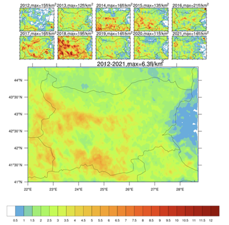
Source: Tsenova, B. D. & Gospodinov, I. (2022), Climate, 10, 184.
07 / HAIL
Bulgaria is among the European countries most exposed to hail.
Geographic position and complex orography create favourable conditions for hailstorms. The highest number of hail days occurs in the mountainous southwest, while the Black Sea coast and parts of northwestern Bulgaria record fewer events.
average hail days per year
average hail days per year
A statistically significant positive trend in the average annual number of hail days has been identified for Bulgaria for both 1991–2022 and the longer 1961–2022 observation periods.
08 / EXTREME PRECIPITATION
Extreme rainfall is becoming a more important component of Bulgaria’s precipitation regime.
Studies identify increasing intensity and frequency of potentially hazardous precipitation in Bulgaria since the beginning of the twenty-first century. Events are classified using precipitation thresholds that correspond to the red-warning threshold in the Meteoalarm system.
within 24 hours
within 24 hours
of these events are associated with powerful convective storms
09 / WHERE EXTREME RAIN CONCENTRATES
The strongest precipitation hotspots are concentrated in specific parts of the country.
The Rhodopes and Strandzha record the highest annual frequency of extreme precipitation, while mountainous areas and the far northeast also stand out from the national pattern.
Spatial distribution across Bulgaria for the period 1931–2019.
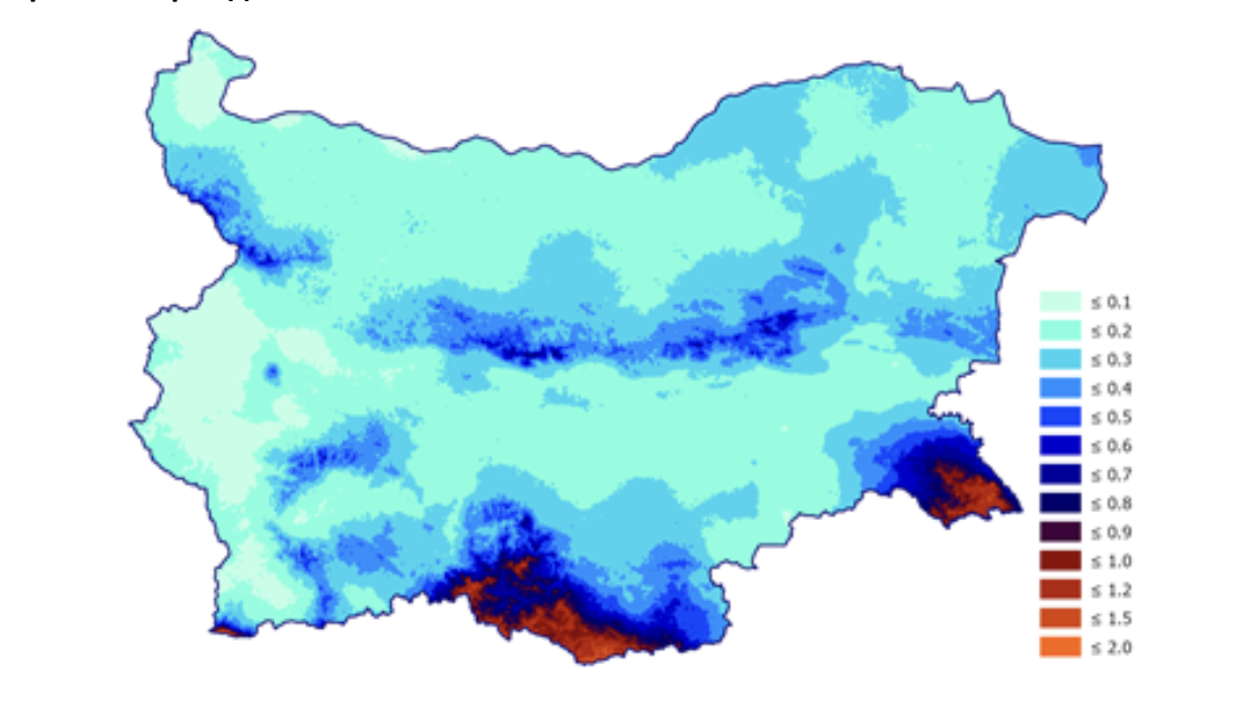
The highest frequency of extreme precipitation.
Elevated frequency in mountainous terrain and the far northeast.
Lower average annual frequency.
Source: Bocheva, L. & Malcheva, K. (2020), cited in the Climate Change Report for Bulgaria.
10 / THE EAST IS CHANGING
Extreme rainfall days have increased sharply in eastern Bulgaria and along the Black Sea coast.
Since 1991, eastern Bulgaria and the Black Sea coast have experienced a statistically significant increase in the average annual number of days with extreme precipitation. Their frequency has expanded across the period from May to November.
increase in the average annual number of days with extreme precipitation in eastern Bulgaria and along the Black Sea coast.
11 / TORNADOES
Tornadoes are rare, localised and difficult to observe — but they are part of Bulgaria’s severe-storm climate.
Documented tornado cases occur mainly in mountainous parts of Bulgaria, particularly in southwestern, northeastern and central regions. Their strong spatial localisation also makes systematic observation difficult.
Almost all documented tornado cases occur during the warm half of the year. Analyses also indicate an increase in the number of weak tornadoes recorded in Bulgaria.
12 / LOOKING AHEAD
The largest future changes are expected around the Black Sea, the Rila–Rhodope region and the Balkan Mountains.
Future climate simulations indicate substantial changes in extreme convective precipitation. Seasonal projections point to particularly strong increases along the Black Sea coast during autumn and across Bulgaria during winter.
extreme precipitation cases projected for 2021–2050.
cases projected for 2071–2099.
projected increase in heavy precipitation.
13 / THE BIGGER PICTURE
Severe convective storms are becoming a growing infrastructure risk.
Climate analyses show an increasing frequency and intensity of phenomena associated with powerful convective storms, particularly since the beginning of the twenty-first century. Heavy precipitation is becoming more intense at both hourly and daily scales.
More intense rainfall increases the potential for rapid flooding.
Heavy precipitation can trigger slope instability and cascading impacts.
Strong winds, hail and intense precipitation increase physical damage risks.
Chapter author: Assoc. Prof. Liliya Bocheva, PhD, National Institute of Meteorology and Hydrology (NIMH)
 English
  Bulgarian